After a leisurely start which included a MacDonald's breakfast we rolled east out of Hope on Highway 3. However, and this may only happen in small towns, there was a booth filled with 'vintage gentlemen' who were all drinking coffee and joking with each other with the ease and familiarity that comes with years of friendship. When we arrived there were about seven people in the booth. When we left two more had crammed in, and a further two had pulled up chairs. We could overhear the banter and it was readily apparent how much these guys like one another. I suspect that many of them have know each other from their school days.
As we got up to leave I offered to give away my coffee sticker as did Garry. One guy snagged them both while the others ragged on him for being the cheapest guy there. Good fun with good friends. It is great to see. In both May and July I saw the same sort of thing in the Tim Horton's in Creston, BC. Maybe that kind of thing only happens in small communities where people have known each other forever. I hope that it happens in more places than I think it does.
Back to the ride. After checking our tire pressures at the Shell station we aimed our bikes east and into Manning Park. The park symbol is a marmot and there is a large wooden carving at one at the entrance so we stopped to take a photo then carried on. The ride to Princeton is more than 130 kilometres and after a few photo stops we carried on.


The Manning Park Marmot
During the First World War there was a terrific demand for copper in all sorts of applications from bullets to telephone wire, to the wire used in electric motors and southern BC had several large copper mines and smelters. At Princeton the Kettle Valley Railway actually built a spur to the Copper Mountain mine in 1920. As we approached Princeton we could see the huge piles of rock that have been moved from the mine and placed on the side of the mountain. It is impressive. There was also another large mine at Phoenix, between Greenwood and Grand Forks that fed a huge smelter at Granby, near Grand Forks. Another large smelter was built at Greenwood, but it was closed right after the War when copper prices collapsed. All that is left there now is a huge slag heap and the smokestack from the smelter.
Our plan to refuel in Princeton was dashed because the Chevron station was shut down because of a power outage. We generally try to use Chevron gas whenever we can because they sell 94 octane gas with no ethanol which is nasty stuff when it is used in small engines like those in motorcycles. The plan changed and we figured that Keremeos would be a good place to get gas.
Between Princeton and Hedley, and yes the band is named after the town, we stopped at Bromley Rock Provincial Park. The park is named for a rock cliff that rises about fifteen metres from the Similkameen River and it is not unusual to see people jumping from the rock into the deep pool below. Not for me, I'm afraid.

Bromley Rock & Similkameen River

The beautiful Similakmeen River
However, I did meet a couple who were being swarmed by yellowjacket wasps because the man had a open can of Pepsi. They were driving an immaculate 1957 Chevrolet, one of the best looking cars that General Motors has ever produced. They have put a lot of money into bringing it back to as close to original condition as they can. In the past few years he has driven this car more than 36 000 miles and has been to Las Vegas, Idaho, California, Oregon, and other states.

1957 Chevrolet at Bromley Rock Provincial Park
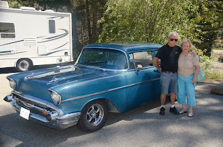
The owners of the 1957 Chevrolet
I mentioned that he seemed to be a guy who loved Chevys and he, in passing, mentioned that he also had three more Chevys; a 1962, a 1963, and a 1964 at home in Merritt, BC. It would be great to see all of those cars together. He also has a 1936 Chevrolet that he is restoring as well. This is a guy with passion!
One of the five bridges that the VV&E Railway built over the Similkameen River in 1907 still survives. It is now a highway bridge but it is rather striking because it is covered with cladding and painted a striking red. We pulled off the highway to take a few photos before carrying on into Keremeos where we stopped at a fruit stand to buy fresh cherries, peaches and apples. We actually ate half of the cherries and an apple in the parking lot of the fruit stand before we moved on. The peaches and remainder of the cherries were reserved for our evening snack.

The 'Red Bridge' near Keremeos

Through the 'Red Bridge'

Similkameen River

Similkameen River near Keremeos

Landscape at Keremeos
Garry refueled in Keremeos but I held off until Osoyoos. The ride along Highway 3 is just one more amazing section of a journey through some of the most incredible landscapes in Canada. To the west of Keremeos, if you know what to look for you can see the railbed of the old Victoria, Vancouver & Eastern Railway which runs alongside the highway for a good distance. The track was torn up in 1937 so it is mostly overgrown and hard to see but it is a reminder of the hopes that people had for their communities a century ago.
On the way to Osoyoos we stopped to take photos of Spotted Lake, a small body of water with circular formations on the water's surface. A sign on the gate at the entrance to the lake notes that this is a medicine lake for the native band that owns the land, but gives no details about what that means. Still, it is an unusual sight.
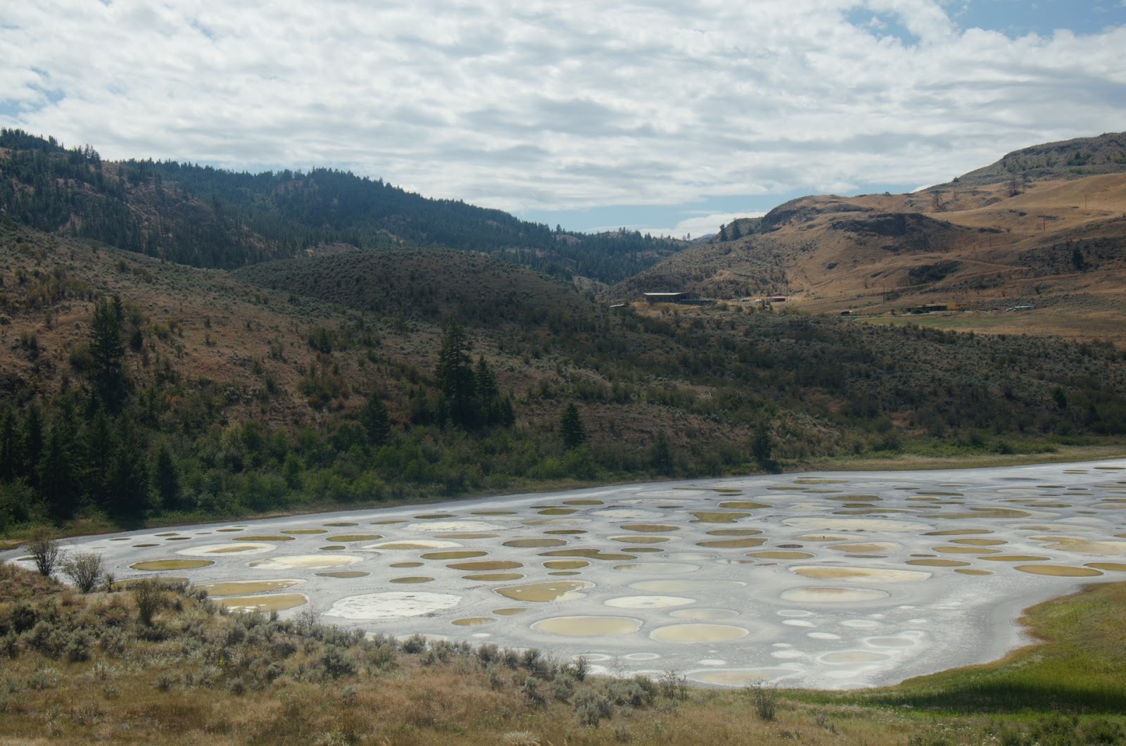
Spotted Lake near Osoyoos, BC

Spotted Lake with circular formations on the water.
The temperature was decidedly warm in Osoyoos and riding in the hot sun with a full set of black leathers might strike some as foolish. At times I am tempted to agree but it's what we do.
Osoyoos is a tourist town during the summer and the beaches were filled with people as we rode east and began to climb as the highway snaked its way up Anarchist Mountain. There is one viewpoint on the road and it allows a panoramic view of the Okanagan Valley including Okanagan Lake and Osoyoos. It is quite impressive.

View north over Osoyoos and Okanagan Lake

View over Okanagan Lake to the south

Osoyoos with Highway 3 to the west.
Without stopping except to take a photo of a forlorn abandoned farmhouse, we rode through Midway and Greenwood finally rolling in to Grand Forks. Garry took a detour to have a look at a house where he spent part of his childhood. We stopped in the street but when two women at the front door began to look at us suspiciously we left. As we made our way down the main street Garry also pointed at another house which he explained was the first house he had lived in.

We made the decision to ride the ninety-seven kilometres to Castlegar before calling it a day. After passing through Christina Lake we climbed from about 275 metres to 1535 metres at Paulson Summit. Along the way we crossed the Paulson Bridge which spans a canyon and a small creek. At this altitude, despite the fact that we had earlier experienced temperatures in the mid thirties, when we hit spots that were in the shade, the temperature dropped so that it was actually chilly in places.

Evening snacks
After more than 480 kilometres we called I a day when we pulled in to the Cozy Pines Motel. Judging from the number of vehicles here, the place doesn't appear to be too busy. The manager told us that there was a Safeway in Castlegar and after unpacking I rode into town, and, to my surprise, there was a Starbucks. We figured that we wouldn't be able to enjoy our favourite coffee brew, (note that I qualified the word 'brew'). So, tomorrow morning, the first order of business will be to stop at Starbucks for a 'real' coffee. Just a little added bonus to an already awesome beginning to our journey to Sturgis.
No comments:
Post a Comment