Friday 31 July 2015

S#*t Happens

Sometimes plans don't work out. On this trip we had planned on riding the Highway to the Sun but last night Garry found that the highway was closed because of a forest fire so we decided to ride into Waterton and Glacier Parks without doing that part of the ride.
 
Before we left Fernie we stopped for our morning Starbucks coffee. From the parking lot the mountains stood out in the morning's light so I stopped to take some photos before we left for Sparwood. When Garry bought his new phone the sales person didn't off him insurance against damage so he had to make arrangements to stop at the Telus dealer in Sparwood to do all the things he had to do.
 
Mountains around Fernie, BC


Leaving Fernie, BC

 
I stopped to take more photos and met him at the dealer. Because it was going to take some time I went ahead to the museum and to see the world's largest truck that had been used in Sparwood in the 1970s. The scale of this thing is massive. The truck itself weighs 250 tons and has a payload of 360 tons for a total of more than six hundred tons. In addition to the two huge front tires it also has eight more under the box. The numbers for the amount of fuel it used and the electricity that it produced are amazing. The information on the sign said that the truck produced enough electricity to power 3200 homes. Incredible!
 
The Terex, the world's largest truck

Payload capacity: 360 tons

Truck weight: 250 tons


Tires are about three metres high.

 
Garry met me at the museum and before we left I gave our remaining cherries to a young family with two children. The kids were delighted and the little guy ran over and gave me a hug.
 
Sparwood is near the Alberta border and the entrance to the Crowsnest Pass. The ride through the mountains here is impressive. This is another beautiful part of our country and this was the first time I had ever seen it. I had never been through the Crowsnest Pass before, even though I had known about it from reading Canadian history when I was in high school. I have waited too long. The ride is incredible, especially a section of the highway that runs between two lakes. I'm glad I saw that.
 
The Crowsnest Pass
 
As you enter Alberta there is a visitor centre that sits in a scenic setting. There are mountains in every direction. I imagine that the people who work here really appreciate the beauty of their surroundings. The women at the counter were really helpful as we planned how we would do our ride into the United States. However, this was the first time today that s#*t happened.
 
View east of Sparwood, near the village of Crowsnest.

Views from the Alberta Tourist Visitor Centre


I left the centre to get a bottle of PowerAde from my motorcycle. When I got close to it I saw a bright spot on my rear tire. Upon closer inspection it looked like I had picked up a nail, and having a nail in your tire when you ride at 110 kph is not a good thing. Immediately plans changed. Now, instead of turning south at Pincher Creek and entering the US through Waterton National Park, we now had to make the 150 kilometer to Crowsnest Trail H-D in Lethbridge, AB.
 
Further on we came to the Frank Slide. At 4;10 a.m. in the morning of April 29, 1903 a huge slab of rock slid off the face of Turtle Mountain moving across the valley below and wiping out about one third of the town of Frank, AB, killing more than seventy people. The scale of the slide is massive and it is estimated that eighty-two million tons of rock slid into the valley and part way up the slope of the neighbouring mountain.
 
Views of the Frank Slide

Turtle Mountain


The interpretive centre above the location of the slide gives a good view of how far the debris travelled across the valley and gives an explanation of why the slide occurred. It was a horrible, but very impressive event and I think it dwarfs the Hope Slide that happened near Hope, BC in 1965.
 

Riding through the Frank Slide
 
One of the things that can make a ride difficult is a strong wind. When we moved into more open ground we experienced strong cross winds that buffeted us quite a lot. When you are riding at 110 kph it can be somewhat disconcerting. It seems though that someone in Alberta has decided to harvest the wind because as we rode east we saw hundreds of windmills. With the price of generating power from fossil fuels and the regularity of the wind blowing, this seems like a natural fit.


This was Friday afternoon of a long weekend in Canada and the weekend before Sturgis so with the number of riders on the road, H-D dealerships are busy and sometimes it is difficult to get work done. On our way to the dealership we stopped in Pincher Creek to refuel. While we were there a group of riders arrived to gas up as well. I spoke to one of them and the guy said that the group was heading to Sturgis.
 
Because it was Friday afternoon we had no time to waste so we did the next 110 kilometres without stopping and we arrived at the dealership at a little after 2:00 p.m. Initially, the owner of the dealership was reluctant to take on the work because they were busy and they were going to be closed on Saturday. When he looked at the rear tire he realized that there was a screw in it and that the tire would need to be changed so he put his technician, Adam, on the job. By the time he changed the tire and took my motorcycle for a check ride it was 4:30.
 
This was when the second bit of s#*t happened. Adam returned from the check ride and told me that the engine compensator was going and that it could fail at any time. In addition, they were closed on Saturday and they didn't have a compensator in stock anyway. Adam suggested that I contact Big Sky H-D in Great Falls, MT to see if they had a compensator and if they could install one tomorrow. Garry made the call and explained the situation. They had the part in stock but it was up to me to get to Great Falls and deliver my motorcycle to the dealership before 9:00 a.m.
 
With a part that was going to fail at any time, my only choice was to make the 310 km run as quickly as possible. We rolled out of the dealership at about 4:45 and headed toward the border. We arrived at the Sweetgrass, MT border crossing in about an hour but then had to wait as the lines going through the crossing moved incredibly slowly. Along with us there were at least a dozen people on motorcycles who were heading to Sturgis as well.
 
After successfully entering the US almost immediately we saw dozens of oil wells in the what fields just south of the border. In juxtaposition to this was a large number of windmills generating electricity, just as in Alberta. and just as in Alberta we experienced heavy crosswinds which tossed us around despite the fact that we were riding reasonably heavy motorcycles.
 
Our next stop was Shelby, MT where we refueled. Again, about ten motorcyles arrived. All were on their way to Sturgis. It has been amazing to see the number and variety of people who are heading to the motorcycle Mecca of the world this weekend.
 
When we hit US15 I dialed my bike in to 120 kph and headed toward Great Falls, 134 kilometres away. As i rode, the though of my engine blowing up was never far from my mind so I tried to keep my speed steady without putting too much stress on the engine. Long, story short, we arrived in Great Falls, having taken three hours and five minutes to make 308 kilometres. Even with the delay at the border and the stops for gas in Shelby, we averaged more than one hundred kilometres per hour. I think that this was the longest and fastest high speed run I've ever done, and Big Red handled the challenge like a champion. I love this bike.
 
After checking in to the Motel 6 we walked over to a restaurant called Beef Obryan's where we each ordered a rack of ribs. They were huge. Garry ate more than half of his before he gave up. I plowed through half of mine before calling it quits. I asked the waitress to wrap the leftovers and took the package back to the motel. Motel 6 doesn't have fridges in their rooms so when I entered the lobby I had the idea to offer the lady behind the counter my ribs. She gratefully accepted so I didn't have to deal with them tomorrow and I did my good deed for the day.
 
So, the plan is to get my motorcycle to the dealership before 9:00 a.m. tomorrow and hope that they can fix it in time for us to ride a bit closer to Sturgis. In some respects, today was a bit of a crappy day, but we did make it to Great Falls, Big Red ran flawlessly, and we are set to get things taken care of tomorrow. On balance things sort of evened out except for the fact hat buying and having a new tire installed cost me more than five hundred dollars. I hope tomorrow doesn't cost me that much.


Thursday 30 July 2015

A Beautiful Day to Ride

Often when I'm on a motorcycle trip I run into fascinating people while on other days, the emphasis is on the ride. Today was one of those days. We really didn't stop anywhere for much time so it was one of those days to enjoy the ride.
 
The day started with a stop at Starbucks in the Safeway store in Castlegar and then we were on the road. East of Castlegar Highway 3 climbs out of the valley and into the mountains. From a temperature in the high 20s, it grew cooler as we climbed and when we reached the top of the pass it was quite refreshing.
 
Between Castlegar and Salmo

Between Salmo & Creston

 
The ride between Castlegar and Salmo was a great start to the day with light traffic. We quickly made it to Salmo and the beginning of the Salmo-Creston Skyway. The highway topped out at 1734 metres and the temperature was perfect. The only drawback was that about twenty kilometres of the road had just been seal coated and the riding was not great. The ruts caused our motorcycles to feel like they were wandering and there was always the concern that approaching traffic would throw up rock chips. It seems as if that didn't happen, but we were glad to see the end of that section of the highway.
 
For the fourth time this year for me, and the second for Garry, we arrived in Creston. After stopping for a short break we headed out of town, making a short stop at a local farm to buy fresh Lapin cherries. The samples we had were so tasty that I bought two pounds of them.
 
Once again, the ride was just excellent. The country here is beautiful during the summer and today was an outstanding day. We stopped at Yahk, BC with the hope that we might see a CPR train passing through but it was not to be. We did however, make a good dent in one of the bags of cherries before we hit the road for the last seventy kilometres to Cranbrook.
 
Yahk, BC: Highway 3 and the CPR line

 
On the way in to Cranbrook we crested a hill and saw the Rocky Mountains for the first time. The sight was almost breathtaking and a harbinger of things to come on the east side of the city.
 
On the west side of Cranbrook there is a large railway museum but most of the locomotives and cars are outside and exposed to the elements. Cranbrook gets good winter weather so many of the exhibits are showing the results of that exposure. I suspect that the museum is run by volunteers and keeping all of the rolling stock in good condition must be a daunting task.
 
Our first stop in Cranbrook was at Harley-Davidson of the Kootenays to deal with a slight leak in my brake fluid reservoir. The service writer tightened the screws and cleaned off the leaked fluid. Next was a visit to Telus. Garry's personal cell phone has been malfunctioning and he decided to buy a new one in Cranbrook before we cross into the United States tomorrow. Since the process of activating the phone and changing his accounts took time, I rode to Starbucks mainly because of their excellent air conditioning which was welcome because the temperature was in the mid-thirties.
 
Harley Davidson of the Kootenays. Lots of motorcycles.

 
The last leg of today's ride was the hundred kilometres to Fernie. As we rode east the Rocky Mountains became more prominent. In addition traffic became quite heavy. One of the frustrating parts of this part of the ride was that there were very few passing lanes and although there were many dotted lines it seemed that there was very little traffic when there were double solid lines, but when we had broken lines there was almost oncoming traffic. Sitting behind a motor home dawdling along at eighty kilometres per hour in a one hundred kph zone is decidedly frustrating. Even incredible scenery does little to relieve that frustrating feeling.


Three views of a mountain east of Cranbrook


As we approached Fernie the mountains were closer and more spectacular. The highway twisted and turned following the contours of the land. The last fifty kilometres to Fernie was some of the most scenic we have seen yet. And we have seen quite a lot of beautiful country over the past three days.
 
 
The road to Fernie, BC

 
As we entered Fernie we made the decision to stop at the Super 8 motel, so we haven't yet actually been in Fernie yet. That will happen tomorrow because we found that Fernie has a Starbucks and we plan on Starting our day there. Across the highway a small river runsby and after we settled in I took some photos. To my delight, I saw a fly fisherman in the river. For me there's something special about seeing a person fly fishing. I think it's the combination of patience and skill that a good fly fisherman must have t be successful. In some ways a lone fly fisherman standing in a clear stream is iconic. Anyway, it is always a sight that I enjoy.
 
Across the highway from out motel in Fernie, BC

Fly fisherman on the Elk River in Fernie, BC.

Another view from our motel in Fernie, BC

Berries along the Elk River

Another view of the Elk River and mountains beyond.

 
Tomorrow we will ride into Alberta then turn south through Glacier National Park before making the decision on which highway we will take in Montana. Our original plan was to ride the Highway to the Sun but this evening Garry found out that the road is closed because of a fire. That's a bit of a disappointment but we'll cope. We covered only 340 kilometres today but it was a very good day and tomorrow promises to be a great one as well.


Wednesday 29 July 2015

Serendipitous Discoveries

After a leisurely start which included a MacDonald's breakfast we rolled east out of Hope on Highway 3. However, and this may only happen in small towns, there was a booth filled with 'vintage gentlemen' who were all drinking coffee and joking with each other with the ease and familiarity that comes with years of friendship. When we arrived there were about seven people in the booth. When we left two more had crammed in, and a further two had pulled up chairs. We could overhear the banter and it was readily apparent how much these guys like one another. I suspect that many of them have know each other from their school days.
 
As we got up to leave I offered to give away my coffee sticker as did Garry. One guy snagged them both while the others ragged on him for being the cheapest guy there. Good fun with good friends. It is great to see. In both May and July I saw the same sort of thing in the Tim Horton's in Creston, BC. Maybe that kind of thing only happens in small communities where people have known each other forever. I hope that it happens in more places than I think it does.
 
Back to the ride. After checking our tire pressures at the Shell station we aimed our bikes east and into Manning Park. The park symbol is a marmot and there is a large wooden carving at one at the entrance so we stopped to take a photo then carried on. The ride to Princeton is more than 130 kilometres and after a few photo stops we carried on.

The Manning Park Marmot

 
During the First World War there was a terrific demand for copper in all sorts of applications from bullets to telephone wire, to the wire used in electric motors and southern BC had several large copper mines and smelters. At Princeton the Kettle Valley Railway actually built a spur to the Copper Mountain mine in 1920. As we approached Princeton we could see the huge piles of rock that have been moved from the mine and placed on the side of the mountain. It is impressive. There was also another large mine at Phoenix, between Greenwood and Grand Forks that fed a huge smelter at Granby, near Grand Forks. Another large smelter was built at Greenwood, but it was closed right after the War when copper prices collapsed. All that is left there now is a huge slag heap and the smokestack from the smelter.
 
Our plan to refuel in Princeton was dashed because the Chevron station was shut down because of a power outage. We generally try to use Chevron gas whenever we can because they sell 94 octane gas with no ethanol which is nasty stuff when it is used in small engines like those in motorcycles. The plan changed and we figured that Keremeos would be a good place to get gas.
 
Between Princeton and Hedley, and yes the band is named after the town, we stopped at Bromley Rock Provincial Park. The park is named for a rock cliff that rises about fifteen metres from the Similkameen River and it is not unusual to see people jumping from the rock into the deep pool below. Not for me, I'm afraid.
 
Bromley Rock & Similkameen River

The beautiful Similakmeen River

 
However, I did meet a couple who were being swarmed by yellowjacket wasps because the man had a open can of Pepsi. They were driving an immaculate 1957 Chevrolet, one of the best looking cars that General Motors has ever produced. They have put a lot of money into bringing it back to as close to original condition as they can. In the past few years he has driven this car more than 36 000 miles and has been to Las Vegas, Idaho, California, Oregon, and other states.
 
1957 Chevrolet at Bromley Rock Provincial Park

The owners of the 1957 Chevrolet
 

I mentioned that he seemed to be a guy who loved Chevys and he, in passing, mentioned that he also had three more Chevys; a 1962, a 1963, and a 1964 at home in Merritt, BC. It would be great to see all of those cars together. He also has a 1936 Chevrolet that he is restoring as well. This is a guy with passion!
 
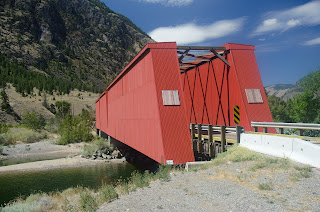
One of the five bridges that the VV&E Railway built over the Similkameen River in 1907 still survives. It is now a highway bridge but it is rather striking because it is covered with cladding and painted a striking red. We pulled off the highway to take a few photos before carrying on into Keremeos where we stopped at a fruit stand to buy fresh cherries, peaches and apples.  We actually ate half of the cherries and an apple in the parking lot of the fruit stand before we moved on. The peaches and remainder of the cherries were reserved for our evening snack.
 
The 'Red Bridge' near Keremeos

Through the 'Red Bridge'

Similkameen River

Similkameen River near Keremeos
 
Landscape at Keremeos
 

Garry refueled in Keremeos but I held off until Osoyoos. The ride along Highway 3 is just one more amazing section of a journey through some of the most incredible landscapes in Canada. To the west of Keremeos, if you know what to look for you can see the railbed of the old Victoria, Vancouver & Eastern Railway which runs alongside the highway for a good distance. The track was torn up in 1937 so it is mostly overgrown and hard to see but it is a reminder of the hopes that people had for their communities a century ago.
 
On the way to Osoyoos we stopped to take photos of Spotted Lake, a small body of water with circular formations on the water's surface. A sign on the gate at the entrance to the lake notes that this is a medicine lake for the native band that owns the land, but gives no details about what that means. Still, it is an unusual sight.
 
Spotted Lake near Osoyoos, BC

Spotted Lake with circular formations on the water.

 
The temperature was decidedly warm in Osoyoos and riding in the hot sun with a full set of black leathers might strike some as foolish. At times I am tempted to agree but it's what we do.
 
Osoyoos is a tourist town during the summer and the beaches were filled with people as we rode east and began to climb as the highway snaked its way up Anarchist Mountain. There is one viewpoint on the road and it allows a panoramic view of the Okanagan Valley including  Okanagan Lake and Osoyoos. It is quite impressive.
 
View north over Osoyoos and Okanagan Lake

View over Okanagan Lake to the south

Osoyoos with Highway 3 to the west.
 
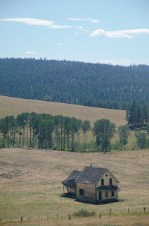
Without stopping except to take a photo of a forlorn abandoned farmhouse, we rode through Midway and Greenwood finally rolling in to Grand Forks.  Garry took a detour to have a look at a house where he spent part of his childhood. We stopped in the street but when two women at the front door began to look at us suspiciously we left. As we made our way down the main street Garry also pointed at another house which he explained was the first house he had lived in.


We made the decision to ride the ninety-seven kilometres to Castlegar before calling it a day. After passing through Christina Lake we climbed from about 275 metres to 1535 metres at Paulson Summit. Along the way we crossed the Paulson Bridge which spans a canyon and a small creek. At this altitude, despite the fact that we had earlier experienced temperatures in the mid thirties, when we hit spots that were in the shade, the temperature dropped so that it was actually chilly in places.
 
Evening snacks

 
After more than 480 kilometres we called I a day when we pulled in to the Cozy Pines Motel. Judging from the number of vehicles here, the place doesn't appear to be too busy. The manager told us that there was a Safeway in Castlegar and after unpacking I rode into town, and, to my surprise, there was a Starbucks. We figured that we wouldn't be able to enjoy our favourite coffee brew, (note that I qualified the word 'brew'). So, tomorrow morning, the first order of business will be to stop at Starbucks for a 'real' coffee. Just a little added bonus to an already awesome beginning to our journey to Sturgis.