Thursday 18 August 2011

The Final Run

I have waited a few days to do the final blog entry for this trip because I wanted to get the feel of home again.  While the trip was an epic journey and one of the adventures of my lifetime, being back home puts it in perspective.  Travelling and seeing new and wonderful things each day is a terrific thing to do, but there is a reason, other than financial, that we don't do it all the time.  We all need to have our own place rather than moving to and from others' places.

When I was preparing to leave Burlington on Friday morning, I experienced two familiar things that had been absent for the past five weeks.  First, the day began with a covering of fog, the first I have seen for a long time, but for me, a reminder that I am back on the West Coast.  Second, the morning temperature was a little cooler and decidedly damper than I have been used to.  That, to me, is a harbinger of autumn, even if it is a month early.  I was glad to experience this and was looking forward to being home,  but I was also somewhat saddened that my adventure was coming to an end.

I left Burlington at about 9:00 a.m. and it was a straight run up I-5 to Bellingham, or so I thought until I came to the worst traffic tie up that I had seen since I was in Joliet, Illinois.  There was road resurfacing going on south of Bellingham and the traffic control was poor and combined with fairly heavy traffic, the result was a monumental slowdown that lasted for more than a kilometre.

After getting through that bottleneck, I was able to move along quickly through Bellingham to the Canadian border.  I love going to the Duty Free shop at the truck crossing.  I am an afficionado of single malt Scotch and the opportunity to pick up a bottle of Scotland's finest at about half price is too goood to pass up.  I was able to buy a litre of Macallan's Five Cask for $55.00, a real bargain.  Leaving the Duty Free, I was able to drive right up to the Customs booth without a delay.  After a passport and license check, I was passed through only to see an incredible traffic line up that was at least a kilometre long heading south to the US.  Sometimes it's good to go against the flow!

Discovery Passage from the beach near our house

Float plane leaving the Spit, Campbell River

Painter's Lodge, Campbell River

The ferry ride was uneventful and before getting on the freeway, I stopped in Nanaimo to talk to the owner of American Heritage Cycles.  While I was in Sioux Falls, SD I met a rider from Alabama who said that he had lived in Nanaimo, and who had asked me to pass on his regards.  Rick recognized the fellow and was glad to hear that he was doing well.  I was struck by the strange coincidence of meeting a person halfway across the continent who knew someone that I had met by chance last fall.  Sometimes it is a small world.

Leaving Nanaimo, I headed for home, stopping only in Courtenay for gas, arriving at my house after travelling 12 761 kilometres.  It was strange riding up Rockland Road which I had ridden down five weeks before thinking about what it would be like to return.  Now I was returning and it really didn't feel that I had been gone that long.  It was great to see Darlene again and to reacquaint myself with our place.  It was good to see that the garden had done well in my absence with an abundance of beans, carrots, beets, onions, garlic, and peas.  One of my sunflowers was now three metres tall and another one was more than two metres in height.

View of the harbour from the Foreshore Park, Campbell River
Wood carving, Foreshore Park, Campbell River

Cruise ship Veendam passing Campbell River

Veendam from Foreshore Park, Campbell River

Over the past five weeks I have seen a tremendous amount of beautiful landscapes and sights, but when I arrived home I was struck by the beauty of where we live.  Being away removed some of the familiarity of where we live and allowed me to see it again with fresh eyes.  The sights I saw on my trip were not any more spectacular than the sights I see every day here in Campbell River, and on Vancouver Island.


Coast Range across the Strait of Juan de Fuca (Salish Sea)
Coast Range looking northeast across Quadra Island
Canadian Navy ship across the Strait of Juan de Fuca
View of Johnstone Strait at Seymour Narrows where Ripple Rock was blown up in 1959.
It's great to be home and in my place again.  There are so many places to go and things to see and I can hardly wait to see what comes next.

Saturday 13 August 2011

A Long Haul

After Wednesday's challenging weather I was ready for any improvement although I cannot complain about the conditions I have experienced.  Hot and humid are not really terrible words to a motorcyclist, especially when the alternatives can be rain, hail, lightning, freezing cold, or fog.  On Thursday morning there wasn't a cloud in the sky, but at Missoula's approximately 3200 foot altitude at 7:00 a.m. that is not necessarily a good thing.  I was on the road at about 7:30 hoping to make up some of the distance that I hadn't done the day before.  The temperature was decidedly 'nipply' but, hey, it's the middle of August.  How bad could it be?  About 20 miles into the ride my fingers were feeling a bit tingly and 30 minutes in they were cold.  I had only about 20 miles to go to reach the $50 000 Bar and a hot coffee, and while I had my heated gloves readily available, the wiring harness was in one of my saddlebags and I didn't want to stop to dig them out and have to repack so I pushed on.   I arrived at the Bar about 20 minutes later after about 50 miles of cold riding. 

When I mentioned to the lady at the cash register that it seemed a bit cool this morning, she informed me that the overnight temperature was 34 degrees F., and that it was now 37 degrees.  I was grateful for the hot coffee.  I spoke to a rider from eastern Washington who had ridden from Sturgis to Missoula the day before - a distance of 750 miles - in the uncertain weather.  He said that it had been a long day but he needed to be home today so he pushed on.  I noticed that he pulled a heavy sweatshirt out of his saddle bag and put it on under his jacket before he left.

This place has a bar with literally thousands of Morgan silver dollars embedded in the bar and in sheets of wood that are mounted on the walls.  At last count there were more than 53 000 of these coins on display in the bar.  Many, if not all of the coins, have the names of the people who placed them there.  I noticed one that was put there by a couple from Wetaskiwin, Alberta in 1954, so the bar has quite a history. I can only imagine what it must have been like with the cars of the time, and in the days before the Interstate Highways, what it would have been like to get here.

Silver Dollars embedded in the bar.
More Morgan silver dollars on display on the barroom walls.

As well as being a cafe and bar, the place also sells souvenirs and Montana jewellery, so before I left I bought Darlene a silver bracelet with a gold-type inlay.  By the time I was ready to leave, half an hour later, the sun had warmed up the air considerably so the ride wasn't at all chilly, except in those areas that were still in deep shadows. 

This part of the ride was about 120 miles, or under two hours to Coeur d'Alene, Idaho and I made it in good time.  Two things about the highways in this part of the US.  The first is that there is a lot of new construction and upgrades happening with new bridges and road surfaces being laid down to replace the old, often very rough surfaces.  The second is that instead of asphalt, many of the highways are made of concrete and the line where the pads join is often raised.  You often find yourself riding along with the bike going kathump, kathump, kathump, for miles on end.  The concrete is often much more uneven than asphalt as well so the ride isn't as smooth.  Much of the ride in this section of the highway was two lanes at 65 mph.

The entrance to Coeur d'Alene from the east is along the river and lake of the same name.  It is a beautiful way to enter this city.  After stopping for gas I pushed on to Spokane, WA, where the 1974 World Exposition was held.  Many of the names in the city reflect this.  The two cities are only about 40 kilometres apart and with urban sprawl, there isn't a lot of open country between the two.  Spokane is also a rail centre for the Burlington Northern Santa Fe (BNSF) railroad with trains regularly heading east and west.  In the early 1900s with the explosion in railroad building, Spokane was the centre for the railways in the US that were trying to push into the rich mining country of southeastern BC.  The smelter at Trail was orignally built as part of a railway company owned by a Spokane businessman, Augustus Heinze, and the Columbia and Western Railway which was bought by the CPR in 1898 along with the smelter was built by the same magnate.
This area of Washington State is called the Palouse, and is a fairly flat agricultural area with outcrops of volcanic rock that covered much of this area millions of years ago.  The land is gently rolling farmland that grows hay, grain, and other crops.  Some of the hay is gathered and placed in long high structures that look like old time military barracks covered with tarps.  There are often eight or ten of these structures in one place and businesses sell hay tarps.

As I was in Spokane I saw a BNSF train moving west out of the yard.  After stopping for a while at the Harley dealership I resumed my ride west.  The railway parallels the highway for some distance and about fifty kilometres on I again saw this train, this time rolling along at a good clip, silhouetted against the horizon.  It was a striking scene and a somewhat iconic western one. 

This land is like much of the west, in that in certain areas you can see for a very long distance to the horizon.  They aren't closed in like many people are in cities and in areas with forests.  As I rode along there were several ploughed very large fields.  The heat was causing 'dust devils' to form.  These are like mini tornadoes that form on the ground and pick up dirt and other materials and make columns that can be seen for a long distance.  At one point I counted eight of them in that large field.
Grain field in the Palouse, eastern Washington.
Grain field and ploughed area, the Palouse, eastern Washington

Just as on the Canadian prairies, it is very difficult to get a good cup of coffee, unless your idea of good coffe is Tim Horton's.  The same holds true in this part of the US just as it does in Swift Current, Brandon, and other Canadian cities.  Bozeman is a city with a population of just under 40 000 but it does not have a Starbucks outlet.  For those of us on the west coast who are used to the ubiquitous presence of Starbucks coffee shops (Campbell River has two), their absence is a disappointment, if not a hardship.  And yet, when I stopped in the tiny town of Ritzville which I had never heard of before, on the I-90 beside the Macdonald,s there was a Starbucks. That was my first clue that I was getting close to home!

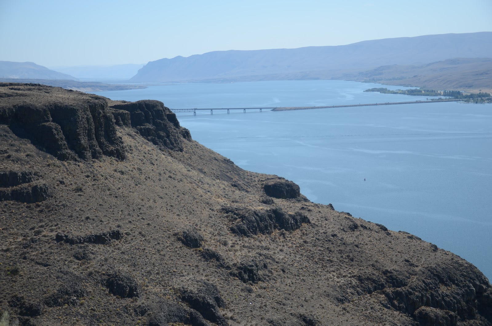
The Columbia River bisects the state and there is a huge lake formed by the Wannapum Dam south of Vantage, WA. where I-90 crosses the Columbia.  On the eastern side of the river there is a viewpoint where you can look down the lake and also see the layers of rock created by volcanic extrusions which occurred between 17 and 13 million years ago and that underly much of the state.  It's a beautiful area and well worth stopping to see.  From the viewpoint you can see for miles both north and south across the river and surrounding area.  Across the river near Vantage there is a huge wind farm with more than 130 windmills slowly turning their blades creating electricity without burning fossil fuels or harnessing rivers.  The wind blows regularly here and this accounts for the placement of the generators.
View to the north of the Columbia River/Reservoir
View to the south with the bridge over the Columbia.
Detail of the extruded rock in this part of Washington.
Big Red at the Columbia River
The riding had been great all day and continued to be so.  I continued on through Ellensburg to the Snoqualmie Pass, which at slightly over 3000 feet would hardly qualify for that title farther east.  The usual afternoon winds picked up and again I faced crosswinds in the open country before the pass.  As I approached the pass the winds dropped but the inevitable road construction and the resulting single lane traffic slowed progress somewhat.  The road has many twists and turns and at 65 mph it is an interesting ride. Some corners have signs advising drivers to slow to 50 mph. Despite all our modern machinery, topography still rules! 
Despite their relatively low altitude, the Cascades are still quite striking.  Many of the mountains still have snow on them at this late stage of the year. 
Near Snoqualmie Pass

Snoqualmie Pass
Leaving the pass I entered the Seattle suburbs from the east.  Traffic in Seattle is very heavy at any time of the day but I had arrived in rush hour.  Fortunately, rather than having to fight traffic in Seattle, I was able to do so on the eastern side of Lake Washington.  While I made between 30 and 40 mph much of the time, at other times traffic was stop and go until I finally merged with I-5 heading north, just south of Everett.  Again traffic was heavy through Everett, but north of there the road opened up and I was able to make good time through Mount Vernon and on to Burlington.  When I pulled in to the motel I had ridden about 950 kilometres, my longest day of the trip. 
Thursday was a great riding day, despite the cold start and it put me a day earlier to getting home.  It is only a 300 km run to Campbell River factoring in the border crossing and ferry ride to the Island.  It's already starting to look like home and that feels good.

Thursday 11 August 2011

From Bozeman to Missoula

When I was riding into Bozeman on Tuesday night along the Gallatin River which the highway follows for perhaps eighty kilometres, I could not help but enjoy the sight of men fly fishing for trout on many sections of the river.  Again, on the ride from Bozeman,  I saw fishermen fly fishing in the rivers to the west of Bozeman.  There is something beautiful about the patience it takes to fish this way, and the skill that it takes to land a fly in just the right place is acquired over years of practice.  The arcs and loops the fishing line makes as it is paid out when the fisherman makes his cast is graceful and a thing of beauty.  There's something idyllic about spending hours in a river attempting to catch a fish with a bit of coloured feather and a hook without the guarantee that one will actually be successful.

I made a late start on Wednesday because I had to replace the front tire on my bike after 31 000 kilometres.  I was able to see downtown Bozeman before I left.  It is a typical western town with brick buildings built in the 1880s and '90s.  I was surprised at the size of the Masonic Lodge and the huge ceramic horse that graced the front of the building.
The ceramic horse at the Masonic Lodge in Bozeman, MT

Street scene, Bozeman, MT

Leaving Bozeman the weather was hot and bright but as I approached the pass between Bozeman and Butte, the afternoon storm clouds showed up again with some rain.  It wasn't much but it was enough to wet the pavement and make riding at 75 mph somewhat challenging.

Storm clouds near the mountains
The rocks in the pass are unusual in that the seem to be rounded and cracked. There was a lot of bare rock with trees growing in the cracks.  The pass rose to more than 7000 feet before dropping down into Butte.  The weather improved again and it was warm and sunny in Butte.  I rode to the Berkeley Pit which took part of Butte in the mid 1950s.  The pit was abandoned in 1983 and is now filling with groundwater and should reach its permanent level by 2023. The downtown is again late 1800s architecture with mainly brick buildings.  The town is showing its age and seems a bit tired. Butte is also the home of the Montana Mining school and they have a museum of mining on campus that is centred on a mine that actually produced minerals.
The Berkeley Pit at Butte, MT

Upon leaving Butte, I again experienced the stormy afternoon weather that seems to be so common here. For most of the ride to Missoula the vicious cross winds made it difficult to stay in the proper lane and the rain again made riding difficult.  After reaching Missoula I decided to call it a day and found a motel room downtown with the hope that Thursday would be a better day.

Wednesday 10 August 2011

Over the Top to Yellowstone

Yesterday was a long day even though I made only about 650 km.  Except for the first 20 km all of my riding was done on two lane roads often with lower speed limits and RV traffic.  For a motorcyclist, the roads were the kind you dream about with lots of twisty turnies and elevation change.  When I crossed Beartooth Pass between Sheridan & Cody, WY, the altimeter on my GPS read 9083 feet.  Part of the road in Yellowstone was over 8000 feet with my highest reading being 8352 feet.  I spent much of the day above 7000 feet and Bozeman, where I stayed last night is at 4200 or so feet.  It definitely is chilly when the sun goes down, or is hidden by clouds this time of year at these altitude.

Sheridan is a railway town and many of the unit coal trains from the Powder River Basin pass through here.  Like many western towns it has a locomotive on display, a 2-8-4 Berkshire type which is across from the original railway station which was built in the 1880s.  These things are impressive even when they are dormant and on display.  Just across the street three big BNSF diesels were idling in front of about a hundred hopper cars filled with coal that was probably going to power plants in the eastern and southesatern US.
2-8-4 Berkshire-type Locomotive on Display in Sheridan, WY

I made the decision last night to ride over the Beartooth Pass to Cody, WY, and from there into Yellowstone Park, so I left I-90 at Ranchester and headed west.  The ride up to the pass was a series of switchbacks with a 30 mph speed limit which was fast enough.  As I climbed I could look back and see the road which I had been on minutes previously, now far below and snaking up the mountain.  One of the really great things that the Wyoming government has done is to erect signs with the names and approximate ages of the rock formations that have been exposed.  These range from 250 to 500 million years old.  I dare anyone who believes in a literal interpretation of the bible to see these formations and then say the earth was created in a week.
Rock formation on the climb to Beartooth Pass. Note the twisting and folding.
Rock formation on the highway to Beartooth Pass
Panorama of the valley below the Beartooth Pass
Some of these rocks are the size of houses!
After passing the summit of Beartooth Pass the road runs through alpine meadows with livestock roaming free.  I actually saw a cowboy riding his horse in one of the meadows.  The highway made a twisting 5000 foot descent toward to valley below.  There were a number of extraordinary sights including Shell Falls which runs over 2.5 billion year old granite which shattered when a fault caused part of the formation to drop about 25 metres.  The canyon and falls are quite striking. 

Lower canyon below Shell Falls
Shell Falls
Rock formations along Shell Creek with storm clouds in the background
Shell Creek
Leaving the Shell Creek Valley I rode into Cody.  Every town here claims some link with Buffalo Bill Cody, including Sheridan, but the town that has his name holds the honour of being the main one. After eight days on the road I'm running short of clean laundry so I stopped at the Cody H-D shop and bought a new T-shirt for tomorrow.  Things get desperate when you're on the road for a long trip!
The Irma Hotel, Cody, WY, Buffalo Bill's favourite hotel, or so it is claimed.
The Yellowstone Park entrance is about 50 miles from Cody but the landscape again, is amazing.  After passing through a narrow canyon that the Shoshone river has carved through limestone over millions of years, the land opens up.  In the early 1900s Buffalo Bill and some others built a dam to save some of the spring runoff for irrigation around Cody and the dam and state park in the area are named for him. 
Buffal Billo Cody Dam & Reservoir
Rock formations beside Buffalo Bill Cody Reservoir
Pile of antlers and jawbones from deer and elk on the way to Yellowstone Park

As I headed to the park from the reservoir the usual afternoon heavy black storm clouds appeared in the west.  I could see lightning and rain but decided to ride until the rain forced me to stop at a small cafe to wait out the rain.  I again was lucky because while I caught a few raindrops I missed the main storm.  The rock formations here are the results of continuous eruptions from the volcanoes that were in the present day Yellowstone Park.  They are thousands of feet thick but very soft and erode quickly.
Shoshone River, west of Cody, WY
Close up of volcanic rock (breccia) deposited by eruptions to the west

I stopped at the entrance to the park to get a photo.  While I was there a group of Japanese, a couple from New Jersey and one from Japan asked me to take their picture at the sign.  I did so and when they were commenting on my bike I asked the man from Japan if he would like to sit on it for a picture. He jumped at the chance, so I told him to put my bike jacket on and they could take pictures.  He was excited about it and said that he would send pictures to his son back in Japan.
Happy Japanese man on my bike at the entrance to Yellowstone Park.
Me at the East Entrance to Yellowstone Park 

As I entered the Park the road began to climb to an altitude on more than 8000 feet.  The scenery, as it has been throughout much of this trip, is amazing.  There are small lakes and waterfalls and the huge central lake that is the caldera of the volcano under Yellowstone which last erupted about 600 000 years ago.  The usual afternoon black storm clouds rolled in on cue, making it difficult to take photos because it was so dark under them.

Kepler's Cascade in Yellowstone Park
Small waterfall in Yellowstone Park

I arrived at Old Faithful at about 5:15 after taking more than two hours to ride the 78 miles from the east gate of the park at an average speed of 35-45 mph.  The eruption was expected at around 5:45, give or take ten minutes. (It is not so faithful after a 1960 earthquake in the area which changed the internal plumbing of the geyser and killed several people at Hegben Lake further west when a landslide caused a huge wave and buried several people who were camping at the lake.)

The mouth of the geyser is constantly steaming and teased the people assembled to watch it with several large blasts of vapour.  The eruption began at about 5:50 and was quite impressive.  It began slowly with several bursts that rose several metres.  It then  became more sustained and the column of water and steam reached a height of about 15 metres.  Eventually it subsided with several smaller pulses then stopped.
Simmering away prior to the eruption

The eruption begins

The main eruption

The eruption subsides
The traffic out of the park was hoorendous and I was keeping in mind the fact that I was not going to be able to get a room until I arrived in Bozeman about 125 miles away.  About ten minutes from the geyser we experienced a traffic jam with stop and go traffic.  It took 25 minutes to go less than a mile.  I was irritated (read really pissed off) when I found that the cause of the delay was rubberneckers almost stopping to get a glimpse of a big bison that was bedded down beside the road.  Several idiots had pulled halfway off the road to get out and take a picture in the crappy light caused by the forest and the storm clouds overhead.  After getting past that the next obstacle was about 8-10 km of loose gravel.  With the number of motorcycles in the park I wondered what genius it was who decided to apply loose gravel to the main highway leading into and out of the park from the north.

I was unable to see a much of what I had hoped to see because of the lateness of the hour and the poor light so it looks like I'll have to go back some day to see it all again.

The ride into Bozeman was about 90 miles from Madison at the entrance to the park and it went well.  Along the way several cars were stopped beside the highway along the Gallatin River.  About 200 metres away a huge grizzly bear was eating plants.  Even at that range it was huge and I was glad that I was: a) on a bike, and b) a good distnace away.  I arrived  in Bozeman just before 9:00 pm after about 650 km and got a cheap motel room.  It was a dump and the Wi-fi didn't work but it wasn't camping. At 6400 feet nights can be quite cold even at this time of year.  The girl at the desk said that this year the snow wasn't gone in Bozeman until late May or early June this year.

Tomorrow I plan on getting a new front tire because: a) the one I have now has 31 000 kms on it, and b) There is no sales tax in Montana and the ship rates are lower here than in BC so I can save some money. The trip is coming to an end and in a few days I will be home.  It will be great but I am going to miss the freedom of the open road.  That may sound like a cliche but it is very real when you do it.  I have been very fortunate to have had the opportunity to do a trip like this and to have had no real problems. Life is good!

Monday 8 August 2011

Leaving Sturgis.

I left the campsite for Strugis at about 8:00 this morning, having decided to put a patch on my motorcycle jacket.  It felt like getting a tattoo.  After taking one last stroll through Sturgis I found a place that would do it and had the patch sewn on and was on the road within the hour. 
My new patch
On the way in to Sturgis I stopped to take a picture of a tree carving advertising a flower shop.  It was sort of like our wood carvings but bigger and done from a tree and painted. It was really striking and quite attractive.  Sometimes you just see neat things and this was one of them.
Shortly after crossing into Wyoming, I took the exit to Devil's Tower but first rode to the town of Aladdin, population 5.  It has a 110 year-old mercantile store which would probably be typical of this type of store in the first half of the last century.
The Aladdin Mercantile interior
Sign outside the Aladdin store

The land has changed and has begun to rise and become rather rolling.  On some sections of the highway one can see for kilometres from the high points.  And the rock formations are a beautiful delicate red shade.  This colour runs from Rapid City well into Wyoming.
Rock formations along the Belle Fourche River, WY
Red rock formations in Wyoming
Cresting a hill I saw the Devil's Tower about fifteen miles away.  Even from that distance it is impressive.  As I appraoched this formation I rode through the town of Hulett where I saw a 1922 Harley-Davidson.  It is amazing that this bike was made when my 89 year-old father was a baby. It was my bad timing to be there on Monday when two days later was 'no panties Wednesday'.  And no, I don't know any more than that but it sounds intriguing!
1922 Harley-Davidson

The Devil's Tower is about nine miles from Hulett and the road was twisty and fun to ride.  From close up this is one of the most impressive geological formations I have ever seen.  It rises directly from the prairie about 1300 feet into the sky.  It was the setting for the 1977 movie, Close Encounters of the Third Kind.  The weather and light was perfect so I was able to get some good photos from close up.  Apparently this was a volcanic intrusion which cooled down so slowly that huge six and seven sided columns formed.  Geologists believe that the last huge piece to fall off the formation did so about 10 000 years ago.

The Devil's Tower

The Devil's Tower

After stopping in Sundance to gas up I made a straight run to Gillette where I stopped at the Harley shop for a break then hit the road again. I continued to meet groups of riders presumably heading to Sturgis. About ten miles west of Gillette I met a group of about eight riders followed by a car and two more riders. As I glanced to my left I was stunned to see one of the bikes behind the car leave the pavement and go into the grassy median ahead of me. The bike was approaching me and fishtailing raising clouds of dust. I hit my brakes but couldn't slow down too much because I was being followed by a semi.  As I met the other bike the fishtailing became more violent and after I passed the bike I watched in my mirror the bike went down in a large cloud of dirt. The people behind him stopped but I continued on because  the semi was close behind me and I couldn't phone for help, I have no medical knowledge, and others were already stopping to help. I did report that I had seen it when I got to Buffalo.
 
Volcanic rock near Buffalo

Panorama near Buffalo, WY

The afternoon storm was approaching so I decided to call it quits for the day in Sheridan, Wyoming. Tomorrow I plan to ride to Cody then push on into Yellowstone Park to see Old Faithful and perhaps Mammoth Falls, The Paint Pots, and other attractions before ending up in Bozeman or Butte, Montana. Today was a shorter ride but I saw a lot. Wyoming and the high plains are really beautiful in a different way than the Canadian prairies.The land is harsher and more intense than I'm used to seeing and I am continually amazed by the work that the pioneers in this land were able to do to survive here.