Thursday 11 July 2013

The End of the Road

After two days' rest at my friends' house in Kamloops it was time to do the final day's ride home to Campbell River.  I left shortly after 9:00 a.m. and headed west on the Trans-Canada Highway (Highway 1) through Savona to Cache Creek.  After a few photo stops overlooking Kamloops Lake and some minor glitches starting Big Red, I stopped in Cache Creek to top up on gas for the leg of my ride between Cache Creek and Squamish through Lillooet, the Duffy Lake Road, Pemberton, and Whistler.

Maggie, the younger of Sue & Jim's two Schnauzers. She has quite a personality.

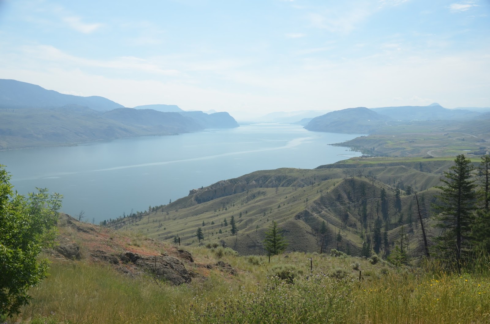
Kamloops Lake looking toward the east and Kamloops.

View to the northeast across Kamloops Lake.

Kamloops Lake
 
When I tried to start my motorcycle nothing happened except for a whine from the starter leading me to conclude that: a) my battery was failing (the simpler and easier problem to deal with) or b) my starter had a major issue (a generally more serious and expensive alternative).
 
I contacted the local towing service to get a jump start and after waiting for forty-five minutes the towing service guy arrived and boosted my battery.  The starter still didn't turn the engine over so the next step was to call Don's Towing in Kamloops and have my bike trailered back to Kamloops H-D.  By the time the tow truck arrived I had been waiting for more than two hours and by the time my bike was dropped off it had been almost four hours and a three hundred dollar towing bill from the time the starter failed. This with a temperature in the high 20s and me in my chaps and vest because I had no place to put my leathers.
 
The dealership was closed on Sunday so I checked in to the Super 8 close by.  Shortly afterwards my friend Jim called and offered to pick me up.  I was able to check out of the room for a reduced rate and spent the night at my friends' house.
 
The next morning we arrived at the dealership prior to its opening and were first in the door.  The service writer put my bike at the head of the line for servicing.  We left the dealership returning an hour later to find that the problem had been fixed and that my bike was ready to go.  I can't say enough about the professionalism and high quality service that everyone in this dealership provides.  I was dealt with as soon as possible and the repairs were done quickly and professionally.  If I lived closer, this would be my favourite H-D dealer.  Because I had previously purchased extended warranty service, the total cost was fifty-six dollars.  And my warranty will cover most of the towing costs so the financial hit won't be too bad.
 
I left the dealership at 10:30 and decided to skip the route through Lillooet and Duffy Lake and take the Coquihalla Highway in order to save time and try to get home at a reasonably early time. The 'Coke' is a four lane freeway with a 110 kph speed limit so it is possible to make good time on it.  The scenery here is equal to anything we saw on our trip.  We live in an incredibly beautiful part of the world and this highway goes through some of the more outstanding parts of it.

On the Coquihalla Highway near the old toll booths.

The granite batholith near the summit of the Coquihalla.

A close up of the batholith

The batholith
 
On the Coquihalla
 
As beautiful as the mountains are this ride was about speed and moving fast in order to catch a ferry to Vancouver Island although I did stop to shoot video of a CP freight train on its way to Vancouver.  After the quick run from Kamloops and a stop in Chilliwack to gas up, I was back on the road heading toward Horseshoe Bay.  Traffic was moving surprisingly well and except for the section near the new Port Mann Bridge I was able to keep to the speed limit. 


Crossing the Ironworkers' Memorial Bridge it was a relatively easy run to Horseshoe Bay where I arrived at 2:50, four hours and twenty minutes after leaving Kamloops.  The ferry ride was uneventful although it was a beautiful sunny day and the coast was its usual spectacular self. 

Near Nanaimo, BC

Looking northeast to the Coast Range near Nanaimo, BC
 
After stopping for dinner in Nanaimo I headed north. The ride from Nanaimo to Courtenay on the Inland Island Highway is fast and safe.  I stopped at the A&W for a drink and found more than fifty bikes in the parking lot.  At this A&W, Monday nights are bike nights and a large number of people show up with  a wide variety of motorcycles  to sit around and talk with other riders and check out their rides.  I met several new people, including 'Lady Di' from Coombs.  She rides an H-D trike and has quite a few tattoos.  Unfortunately, I wasn't thinking and I didn't pull my camera out to get a few shots of the gathering. 
 
After a gas stop  I pushed on to Campbell River and home on the Old Island Highway.  Closer to Campbell River the road runs by the Strait of Juan de Fuca (Salish Sea) and provides many spectacular views of the Coast Range across the water.
 
After two weeks away it was great to be approaching home.  I arrived in my driveway at 8:00 p.m. after 529 kilometres, and after saying 'Hi' to Darlene, I unloaded my bike, parked it in the garage with a new load of smashed bugs on the fairing, ready to call it a day after putting on 4849 kilometres in just over two weeks.

Discovery Pier & the Powell River Queen, Campbell River, BC

The Coast Range behind Quadra Island from Campbell River, BC

Looking north over Chinese Mountain, Quadra Island, BC
Dusk in Campbell River, BC
 
 Except for a few minor downpours and a relatively minor mechanical problem this was a great ride.  Jim is a great guy to ride with and to spend time with off the road as well.  After knowing each other for almost 39 years we finally had the opportunity to do a road trip together and it went very well.  We saw a wide variety of country, met quite a selection of Americans in five different states, took roads that neither of us had ridden before, and generally had an outstanding time, although the 100+F. temperatures that we experienced for several days began to wear on us.
 
It's great to be home, but I'm already looking forward to doing another ride next summer although we haven't figured out just where yet.  However, wherever it will be will be worthwhile.  There's lots of places to go and see and I have a particularly warm spot for the American southwest.  The open country, great roads, spectacular scenery and incredible geography makes it almost impossible not to go back.
 
And there's still lots of riding left to do this summer before the rains begin and it is time to put Big Red away for the winter once again.
 

Tuesday 9 July 2013

The Road(s) Less Travelled


Somehow or other, due to the miracle of excellent planning, Jim and I managed to miss not only the festivities of Canada Day, but also those of July 4th.  I don't know how that happened but we've got to do some serious thinking about this if we plan a trip on those dates in the future.  Everywhere we went we saw evidence that people were gearing up for the annual blowout.  Campers and boats were being prepared, fireworks stand were set up advertising the power of their wares, and Budweiser packaged their beer in patriotic cans with stars and stripes and the red white and blue.  The cans were so eye-catching that we were compelled to purchase a couple of six paks and sample the contents.  We were not disappointed.
 
I'm afraid that I tend to be a bit of a beer snob, pledging allegiance to out local Vancouver Island microbreweries and their excellent beers.  However, Budweiser in tall cans has been a guilty pleasure of mine for more than thirty-five years.  I don't know what it is, but I like the stuff.  Just the American version though.  The Canadian version tastes terrible and after an initial sampling to see how it matched up many years ago, I've avoided it like the plague.  Maybe it's the fact that I get the 'real' Budweiser, 'The King of Beers' only sporadically that make sit so desirable, but whatever the reason, I do enjoy the occasional quaff of the stuff.
 
We finished our ride from Sandpoint relatively early in the afternoon of July 3rd and were able to get the last double room north of Omak, the second time in two days we were able to get the last available room.  Something or someone was looking out for us I guess.
 
 
We left Oroville at about 7:45 a.m. hoping to stop at the duty free, pick up a bottle of single malt Scotch, cross the border, and have a straight run up the Okanagan Valley, ending up at Jim & Sue's house in Kamloops in the early afternoon.  We arrived at the duty free, and it was open before 8:00 a.m. so we were able to choose our beverage of choice without any pressure because we were the only customers in the store.  Jim picked a bottle of 12 year-old Glenlivet called 'The Master' because the master distiller supposedly chose it himself.  I picked up a bottle of Islay malt, Caol Ila which has a distinctly smoky flavor.
 
The border crossing was uneventful. 'How long have you been out of the country?' Are you bringing back any alcohol or tobacco?' and 'Have a good day.'  I little less formal than crossing into the US eight days earlier at the same place.
 
 
Osoyoos if just across the border on the Canadian side so after having the lead for a week and more than 3000 km I relinquished it and Jim took over.  Within two or three kilometres we made a left turn, began to climb, had great views of Osoyoos Lake and crossed the Richter Pass on Highway 3.  We rode to Keremeos, turned right and continued north until we were south of Penticton where we rejoined Highway 97.  When we stopped for gas in Penticton, I commented, "That was an interesting detour."  Jim replied, "I f#@%ed up."  No big deal though because the ride to Penticton the way we did it was far better than fighting traffic up 97 all the way to Penticton anyway.  It was a sort of bonus that we originally hadn't counted on.
 
Both the highway to Keremeos, and then north to Penticton are terrific motorcycle roads with a great deal of elevation change, scores of curves, and a long section that skirts Yellow Lake.  There are few things that make riding better than riding curves alongside a lake.
 
Highway 97 north from Penticton to Summerland parallels Okanagan Lake for what must be close to twenty-five kilometres and offers great views of the mountains on the east side of the lake.  Much of the mountains aren't yet forested after the big fire of 2003 that destroyed tens of square kilometres of forest as well as the Kettle Valley Railway trestles in the Myra Canyon.
 
Okanagan Lake north of Penticton

Another view of Okanagan Lake

Our trusty steeds at Okanagan Lake
Highway 97 runs through Kelowna after passing through Westbank and crossing the floating bridge.  We avoided the traffic and congestion of Kelowna by taking  Westside Road, so named because it runs along the west side of Okanagan Lake for more than 40 kilometres.  The BCAA has designated Westside Road one of the worst roads in the province, but many motorcyclists, Jim and me included, think that it's one of the best rides in the province.
 
Kelowna across Okanagan Lake from the Westside Road.
The road is generally high above the lake leaving the waterfront for all the housing developments that have sprung up along the lake, and it provides a series of wonderful views of the lake and surrounding mountains.  The only thing marring these beautiful panoramas was the excessive number (one or more) of Christy Clark election signs that were scattered along the edge of the road.  Hopefully they'll be pulled up on Thursday and used in another riding next month.  That is, if the people in West Kelowna have any sense at all.
 
The floating bridge over Okanagan Lake between Westbank and Kelowna, BC
 
Okanagan Lake from Westside Road.

Okanagan Lake from Westside Road.

Looking north on Okanagan Lake from Westside Road.

Across Okanagan Lake from Westside Road.
 
The road rejoins Highway 97, north of Vernon.  We headed north and stopped for lunch at the Falkland Inn, a bar that is popular with bikers.  At least every time we ride that way we see several Harleys parked out front.  This day was no different with about half a dozen bikes parked out front.  Some left and others took their places so there was a bit of a turnover.  After having lunch I rode back south to take some pictures of Falkland so I could email them to the owner of High Desert H-D, in Meridian, ID.  When we met him earlier in the trip he mentioned that his wife was from there so I figured that we'd send some photos to him so he could show her, if he wished to.
 
The Falkland Inn
It was less than an hour's run from Falkland, past Monte Lake, then onto the Trans-Canada Highway, across the South Thompson River and on to Jim's place.  We were gone for nine days and did almost 4000 kilometres through some of the most varied country imaginable. 
 
 
But back to the title of this posting.  Except for our run from Kennewick, WA, to Mountain Home, ID, and a short thirty mile stretch west of Bozeman, all of our riding was done on secondary roads.  That is, two lane roads that are not engineered like the interstate highways.  These highways obey the dictates of geography and follow contours, rivers, and sometimes, they just run straight for miles.  Often they were built alongside existing railway lines because those old railway surveyors seem to have had a knack for finding the best way from Point A to Point B and it seems to have made sense to put highways there too.
 
 
As a consequence of taking these roads we rode through and stopped in small towns on our journey,  Places like Moses Lake, WA, Arco, ID, Alpine, WY, Kalispell, MT, Sandpoint ID, and Oroville, WA, are small towns where we got to see the America of yesteryear and of today.  Almost without exception they are deeply conservative and seem to be at odds with the changes that are happening in the more diverse regions of the country.  It was a regular occurrence to begin a conversation about something random and within two minutes be told that America's problems were because of 'that community organizer in the White House.' Or, 'We're losing our democracy,' or, 'The communists are taking over,' because of, you guessed it, 'that community organizer in the White House.'  People in rural Idaho, Wyoming and Montana, were quite open about their dislike of the President.
 
 
It wasn't surprising given that many of the restaurants were went into had Fox News blaring on a TV in the corner, and when we turned on the TV in our motel room, it had been left on Fox News by the previous occupant/s.  And the phrases they were using were almost exactly the same ones heard on that channel.
 
 
In any case, riding those back roads gave us time to enjoy the country.  It was more relaxed because there was little traffic, and people seemed genuinely friendly even when they found out that we were Canadians.  Or despite us being universal health care loving socialists.  This is the way to see America because the country is its people as much as its magnificent scenery and geography.  I love travelling this way with a friend.  It's a great way to see a country that in many ways is similar to ours, but in far more ways, quite foreign.  This trip was so good that already we're thinking of doing another, although shorter trip mostly in Washington State next summer.  There's more roads to explore and people to meet.
 

Wednesday 3 July 2013

Closing the Circle

We are close to completing the large circle that we began seven days and more than three thousand kilometres ago.  Today our plan was to leave Idaho and follow Washington State Route 20 for the border to Highway 97 where we would turn north and stop for the day just south of the border.  Neither of us have ridden this highway before and rather than heading straight west like an Interstate highway, the route of this secondary road is subject to the rugged geography of eastern Washington.
 
Outside our motel in Sandpoint, ID.
 
As I was finishing packing up my bike, Jim, who was already ready to roll, was enjoying a relaxing moment on the bench outside the motel when he was approached by and an older woman who was missing a few teeth.  She talked to him about riding in the heat and mentioned that it must be hot riding in chaps and a jacket.  Jim agreed that it was.  She then commented, "You must sweat a lot."  Jim agreed and she then commented, "That must be how you keep so thin."  Jim was at a loss for words with that.  He explained later, "I had nothing to say. I haven't been called 'thin' in over forty years!" I remarked to him that considering where we were he would be considered thin, considering the many jumbo-sized people we had met on out travels over the past week.

We left Sandpoint, ID, at about 8:30 heading west.  We crossed into Washington at Newport and turned from Highway 2 to Highway 20.  The road change immediately climbing and turning and heading north to Tiger, WA, as we rode along the Pend Oreille River.  The river is fast moving in spots and it is quite broad.  In spots it broadens out and there are cabins and docks along the shore.  The whole area is quite beautiful as it is surrounded by steep tree-covered mountains.
Pend Oreille River near Tiger, WA
 
The run in to Colville was a real pleasure.  This highway is a motorcyclist's dream with constant turns interspersed with long straightaways and the miles flew by.  After leaving Tiger we crossed a pass at 3300 feet, stopping at Crystal Falls, a waterfall that is about sixty or seventy high,  before descending into the valley that is partly covered by Lake Roosevelt, the reservoir created by the Grand Coulee Dam. By the time we reached Colville the temperature was in the low 80s with the promise of going still higher as the day progressed and as we lost altitude.
 

Crystal Falls

Crystal Falls
 
Crossing the Columbia River at Kettle Falls
 
We stopped for lunch in Colville then continued west to Kettle Falls where we crossed the Columbia River and began to climb the second of three passes, this one called Sherman Pass.  The road again climbed in a series of switchbacks and straightaways.  We climbed almost 4000 feet in about twenty miles, topping out at 5575 feet.  The highway then descended to the town of Republic before again climbing into the third of the passes we were to cross today.  This pass topped out at 4300 feet before descending to the town of Tonasket where we turned north on Highway 97 to Oroville.
 
Sherman Pass summit

Looking west toward Kettle Falls, WA

Wolf sculptures at the Sherman Pass summit
 
Republic, WA

Motel in Republic, WA
 
We stopped at the first, and as it turned out, the only motel in Oroville, and just as it happened last night, we got the last room that was available.  Twenty minutes later and we would have had to either cross the border and try to get a very expensive room in Osoyoos or further north, or backtrack and head south twenty-five kilometres to Tonasket or eighty kilometres to Omak.  The gods have been smiling on us the past two days when it comes to accommodation.
 
The past two days have been wonderful riding days.  Today we covered 379 kilometres, almost all of it on roads that were a motorcyclist's delight.  We climbed three mountain passes and except for the stops in Colville and here in Oroville, we didn't meet many other people.  We really didn't see many motorcyclists today and we didn't meet any.  The day was mainly devoted to riding and the scenery, while beautiful, is not as spectacular as some that we have seen in the past week.
 
Tomorrow morning we will visit the Duty Free, cross into Canada (our home and native land!) and ride up the Okanagan Valley then on to Kamloops where we will clean the bikes and sit back and relax for a while.  As an extra treat, we'll turn off Highway 97 just before we get to Kelowna and take the Westside Road.  BCAA says that it's one of the worst roads in BC.  Jim and I think it is probably one of the best biking roads in the province and tomorrow we'll have chance to enjoy it once more.

Tuesday 2 July 2013

Taking It Easy

After yesterday's run in the heat, we decided to take it easier today and our aim was to ride to Sandpoint, ID, a distance of approximately 300 kilometres.  There was a real variety of people staying at the motel.  In addition to the two couples who rode in after us, there was a van load of seven Amish men and women as well.
 
Another picture of an orange H-D.
 
We didn't realize it until this morning when we saw a couple at breakfast, the man dressed in home made blue denim pants, suspenders and a white shirt, and the woman in a home made brown denim dress and a white basket/bonnet thing similar to the one Mennonite women wear near Campbell River.  I spoke to the man as I was loading my motorcycle.
 
He and six other Amish were on a seventeen day vacation to the west coast.  They were from Ohio where he was a farmer.  Their trip took them through the Badlands, Yellowstone Park, and other attractions.  Today they were going to drive through Glacier National Park into Waterton National Park in Canada, then up Highway 93 to Radium, then to Banff.  They were then going to go west to the coast then work their way back to Ohio. 
 
I asked the Amish man if the Amish drive or use modern machinery.  He said that they don't use electricity, or drive cars, trucks, or tractors.  Instead they use horses and buggies to get around and use horses and older machinery to farm and harvest crops.  Their farms are small, averaging between forty and fifty acres, but they have a problem in that their population is growing but they don't have enough farms for everyone, so many of the men become carpenters or woodworkers and are employed building Amish furniture.
 
Because they don't drive, they had hired a van and driver for the journey.  I spoke to the driver and that's what he does for a living.  His wife says he is on vacation for most of the year.
 
As is the case in any place with an H-D dealership, Jim and I had to go and check it out.  Glacier H-D is a small dealership and since we had arrived before opening we had to wait.  I noticed a sign that encouraged anyone with a 'Concealed Carry' permit to carry their guns in the dealership.  When I took a photo of it an older guy in a truck waved me over and told me that if I asked the owner would give me a copy of the sign.  I declined but we began a conversation.
 
The other guy, who was the driver owned a husky/wolf hybrid that was in the back.  The dog was big and had huge paws.  I was able to get photos of the two guys, Bill and Jim, and then a photo of Jim and his wolf-dog, Ghost.  Jim was from Cherokee, South Carolina and had all sorts of stories about how to tame a bear and how he wanted to have a tame wolverine and a domesticated mountain lion.  There wasn't a lot of truth to what he said, but he and Bill provided some real entertainment as we waited for the shop to open.
 

The 'concealed carry' notice on the H-D dealership door.

Jim (l) and Bill (r)

Jim and his wolf/dog, Ghost.

Leaving the dealership, we gassed up and headed west.  For the previous two days riding in Montana we had seen small white crosses on posts beside the highways we rode on.  I estimate that on Sunday we saw at least thirty to fifty crosses between Yellowstone Park and Bozeman, and on Monday, there were probably more between Bozeman and Kalispell.
 
Today I decided to count the crosses to see how many there actually were.  Between Kalispell and Libby, MT, I counted seventy-five crosses, with one site having seventeen crosses.  Apparently a bus carrying a wrestling team crashed there several years ago killing seventeen people.  There were other sites with three, four, and even five crosses.  Between Libby and the Idaho border, a distance of about forty kilometres, I counted an additional thirty-seven crosses, for a total of one hundred and twelve crosses in less than two hundred kilometres.
 
The ride today was a real pleasure as the highway twisted and turned through the mountains.  Interspersed between these sections were long straight sections as well.  While the speed limit was 70 mph, we cruised at about 65 and pulled over to let people pass, and with the sparse traffic, we had the highway to ourselves for most of the way.  Jim saw four deer while I spotted only one. 
 
At the entrance to Libby people have set up a memorial garden with a large metal sculpture of an eagle which is quite striking.  Libby itself is a small town which is about seventeen miles from the dam.  We opted not to make the thirty-five mile round trip to the dam because the heat was increasing and we chose not to extend our ride today.  We took a break at the Subway and spoke to several local men who explained about the white crosses to us.  Apparently the white cross tradition is done only in Montana by the American Legion.  When I passed through Montana in 1977 I first saw these crosses so the tradition has been going on for a long time.
 

The Libby, MT, eagle
 
The next stop was Bonner's Ferry, ID, a small town of about 2600 people on the Kootenai River.  As we left town we passed the local high school which had been built in 1917.  Further on we crossed the Kootenai River and passed through Bonners Ferry, ID.
The highway bridge crossing the Kootenai River, Bonners Ferry, ID

The railway bridge crossing the Kootenai River at Bonners Ferry, ID.
 
The temperature was in the 90s (F) when we arrived in Sandpoint, ID where had decided to stop for the day after a relatively leisurely 289 kilometer day.  We were able to get a room at the Days Inn and wrap up the ride for the day.  Despite meeting several interesting people this morning, we didn't have the opportunity to connect with anyone else today.  One of the highlights of this trip is having the opportunity to meet and talk with people who come from different places and backgrounds.  They all have stories and are delighted to tell them.  And I am interested in hearing them so it all works out.
Kootenai River, near Troy, MT

Kootenai River near Troy, MT
 
Tomorrow we plans on making it to Oroville, WA, and then crossing into Canada on the morning of July 4th.  The ride through western Washington State should be a really good way to spend a day and as long as it doesn't rain, we can deal with the heat.  Neither of us have ridden Highway 20 so it should be another new experience for us.  And that is the whole point of this road trip.

Monday 1 July 2013

Canada Day, 2013

Today is Canada Day, but that doesn't mean anything in the US of A.  Everyone is getting geared up for the 4th on Thursday and probably 90 percent of Americans don't even know that July 1st is our July 4th.  Jim and I will miss the celebrations as we travel through Montana.
 
This morning we were off at about 8:30.  We rode to the centre of Bozeman to see what an 1890s downtown looks like.  The Masonic Lodge seems to be big in Montana and Bozeman's is right on the main street.  Unlike any other Masonic Lodge I've seen this one has a statue of a rearing palomino horse on its corner.  It is certainly striking.

The Masonic Lodge palomino scupture

We left downtown Bozeman and headed to Yellowstone H-D in Belgrade, MT which is just east of Bozeman.  The main purpose, as well as checking out the dealership, was to see if anyone at the dealership could suggest a good ride for us today as we had nothing really planned for the day except to generally head west and avoid I-90.  The person we talked to had several suggestions but the one we liked best had us leaving I-90 about 50 kilometres west of Belgrade, riding north to Helena, then taking secondary roads through northern Montana to Kalispell.
 
We had no real idea of the distance involved but the ride looked good so we made the decision to take this route.  As usual for the past three days, the heat began to build quite early and by the time we reached Helena, the bank thermometer read 91F.  Form I-90 to Helena is mostly farmland with huge fields of wheat which stretch almost literally to the horizon.  After all the desert colours we've seen over the past several days it was a welcome change to see green fields backed by mountains,  for a change.
 
West of Helena the highway began to climb to an altitude of more than 6300 feet as we climbed over Macdonald Pass.  Near the top we stopped at a viewpoint that gave us a tremendous view of the road and landscape that we had just traveled on and through.  If anything it was even hotter as the ride and day progressed.
 
View to the east from Macdonald Pass

View to the south

View to the southeast
 
We stopped at the intersection of Highways 200 and 83 for gas and an ice cream cone.  The memorable aspect of this stop was a huge statue of a Hereford steer.  The last part of the ride was through a valley surrounded by low mountains. 
 
Stoney's Steer

Mountains on the way to Kalispell, MT


The remainder of the ride to Kalispell was through alpine evergreen forest.  It was one of those rides that I call 'industrial' in that the whole point of the ride was just to get to journey's end.  We reached Kalispell just before 5:00 p.m. found a motel and settled in. 
 
As we were leaving to get dinner I took several photos of an orange Ultra Classic which was parked close to our bikes.  The owner came out and we had a good conversation.  He was travelling with a friend from Arizona and had just arrived from travelling in Glacier Park.

Another Orange Harley
 
Today was one of those days when the scenery was mundane and the main point was to get from one place to another.  There were some outstanding sections, including the climb over Macdonald Pass as well as several twisty sections throughout the ride.  It was an OK day, but not as outstanding as yesterday's ride.  In all we covered 482 kilometres today.  The remainder of this trip will be easy rides and our plan is to make it back to Kamloops on Thursday, July 4th.