This morning we got a good start to the day's riding by heading south on Highway 95 from Donnelly, ID to Cascade, ID. This is a tourist area but it didn't seem as if there were many tourists in the area. The weather didn't look promising but then again it didn't look nasty either and that gave us hope that we would avoid the rain showers that were forecast for the area.

Ready to roll from the Long Valley Motel
The temperature was in the high fifties as we left so I made the choice to abandon my fingerless gloves and go with my gauntlets. Good choice, as it turned out. Jim, on the other hand, stuck with his fingerless gloves. All I can say is that he is a tougher man than I, because by the time we had ridden to Cascade my fingers were chilly while Jim carried on as if the temperature didn't matter.

Highway 95 along the Payette River

Railway bridge over the Payette River
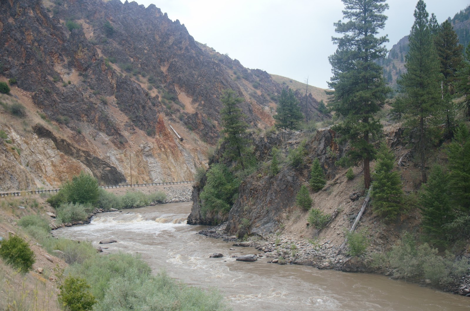
From Donnelly to Cascade is about fifteen miles and south of the town is the entrance to the Payette River Canyon. The highway hugs one side of the river while the railway that runs to Ontario, OR clings to the other side. Rivers don't run in straight lines and neither does this highway which makes it a great motorcycle ride. There are very few places where a rider takes a straight line for more than a few hundred metres. Most of the time is spent leaning the motorcycle as you move from curve to curve. There is no time for inattention on this road.
Highway 95 is like this for quite a long distance.
This time of year road work is fairly common. Toward the end of the canyon we came upon part of the highway that was being chip sealed. This means that the highway is covered with tar then a layer of loose rock chips is placed upon it. During construction it is like riding on loose gravel and today we had about five miles of it. Not a pleasant experience.
Payette River north of Banks, ID
At the village of Banks we took Highway 21 to the east. This road follows the narrow canyon of the South Fork of the Payette River. Again, the highway followed the river so we rode a series of curves with speeds down to 25 miles per hour. The road climbed as we rode east and after passing through Lowman the elevation change became pronounced and we were reaching altitudes of almost 7000 feet. At the first summit there was a pullout with a sign telling about a settler named Emile Grandjean who moved to the area in 1883. It is hard to imagine how a person could survive in the wilderness so long ago when even today the only evidence of human activity is the highway that runs through these mountains.
Right ahead of us a cyclist pulled into to viewpoint. The cyclist was a woman who was self-supported. carrying everything she needed to survive on the road. At that point, she was at least ninety kilometres from the nearest services. She was riding a 1977 ten speed bicycle which in itself was unusual. The woman whose name is Polly is probably close to sixty years old and she has been doing these rides every summer since the early 1980s. She has ridden from Alaska to Mexico and done many long rides in Canada and the US. She lives on Bainbridge Island, WA and has been on the road for two weeks. She is heading to Cheyenne, WY, but doesn't know when she is going to get there. She seems to be quite a character.
Considering that heavy bike she was riding along with her panniers which were loaded with her supplies it was amazing that she was able to ride that bike up the steep hills of this highway. Polly probably weighs about one hundred pounds and her bike with its load probably weighs sixty-five pounds. And, she is probably the skinniest person I have ever seen. Her Body Mass Index (BMI) is probably close to zero. There doesn't look to be a single ounce of fat on this woman.

Polly, the cyclist, heading to Cheyenne, WY
Polly was headed to Stanley, about ninety kilometres to the east and faced several climbs before beginning her descent. We wished her well and resumed our ride. After the Emile Grandjean Summit at 7000 feet, we crossed banner Summit at 7200 feet, then further on Blind Summit at 6850 feet before descending to about 6000 feet for the run in to Stanley, ID, where we stopped for gas and lunch. Stanley is the entry to the Sawtooth Wilderness and the building have a decidedly western theme, looking like they were built from logs. The Sawtooth Mountains provided a beautiful backdrop for this village. At 6000 feet, I wonder what it might be like in mid-January. It's probably not the kind of weather that I prefer.

Sawtooth Mountains near Stanley, ID

Sawtooth Mountains provide beautiful background to Stanley, ID
The weather to the east was looking unsettled and when we were ready to resume our ride it began to rain. We pulled on our rain pants then headed east then north. The rain began immediately and continued for more than an hour. In places it pounded down making it so difficult to see that we were riding at forty miles per hour instead of the posted sixty-five. Again, the highway followed a river, the Salmon this time, with the many turns that rivers and the highways beside them take.
Along the road there was a fumarole and hot spring that sent a cascade of hot water into the Salmon River. People have built a pool with rocks and they lie in the shallow water soaking up the warmth. It looked quite comfortable, but unfortunately we had no time to stop and enjoy soaking in the little pool.

Fumarole and hot spring along the highway east of Stanley, ID

People enjoying the warm water from the hot spring
By the time we reached Challis, ID, our jackets were wet because, although we had rain pants, we didn't have rain jackets. Wet clothing and sixty plus mph can be chilly so we stopped at a small bar for coffee. The rain was falling desultorily as we began the run in to Salmon, ID, but it eventually stopped although the clouds ahead still looked threatening.
The hills along this section of the highway are quite steep with slopes coming right to the edge of the road. In some places rocks were folded in almost impossible configurations. The stresses that it took to bend these rocks like this are unimaginable. I have never seen anything like it.
Riding through a gorge on the Salmon River, ID
As we approached Salmon the weather began to improve and we actually saw the sun poking through occasionally. After 430 kilometres of rain and almost constant twisty roads, we called it quits for the day and easily found a motel room then walked to a brew pub in downtown Salmon where we enjoyed some locally brewed beer along with our dinners. The beer was really good and it is good to support local business, especially when they make a good product.
many of these little towns have public art that reflects what they value and Salmon is no exception. At the end of the bridge that crosses the Salmon River is a small park with a sculpture that says a lot of what the town is about. In addition there is a small museum that tells the story of the settlement of Salmon from the early fur traders in the 1820s to Mormon missionaries in the 1860s to the beginning of mining and logging in the area and the growth of the businesses that supported them. This is a beautiful little town in an absolutely spectacular setting.

Salmon & bear sculpture in Salmon, ID.
Today most of our riding was done on roads that consisted of many series of curves. This was probably one of the best days of motorcycle riding I have ever done. Before we began the trip Jim charted out several rides and this was one of the best. I think in the Idaho list of bike roads, this ride is call the 'Blow Your Mind' loop. It certainly does that. Unfortunately, we don't have time to do more of these rides on this trip so we may have to return next year to do more of them. I had no idea that Idaho had such great bike roads and I'm stoked to do more of them.
Tomorrow we are going to run north to Missoula then head east to Couer d'Alene so that we can return to Canada on Saturday. The weather is looking rather sketchy and I'm afraid that we will be wet more than a few times before we return to Kamloops. Our bikes are the dirtiest that they have ever been and with the potential rain we have decided to leave the dirt until we get back to Kamloops. The next three days will have a lot of rising and with luck, very little rotten weather. At least I hope so.
No comments:
Post a Comment