Friday, 11 July 2025

Trains, Mountains, and History


After yesterday's windy and someone wet ride, it was a totally different beginning with an almost cloudless sky. It's always a great thing when one isn't concerned about rain. However, with Invermere being near the Rocky Mountains, the temperature was a bit lower than I expected at 13C. But at least it wasn't wet and I could look forward to it being warmer as the day went on.

Traffic on the highway was light and I was able to roll along at an easy 100 kph. My first stop was at a viewing area overlooking the Columbia Valley. It is easy to see why people settled here in the 1800s. The land looks great for for farming and in the late 1800s the CPR built a line that ran from the coal mines of BC's southeast up to the main line at Golden. It is still used to haul coal, As luck would have it a coal train was running north below the viewpoint.  

View across the Columbia Vally

Columbia Valley with coal train mid right

I raced ahead to get a viewpoint to see the passing train at a lumber yard in Brisco, BC. The train arrived as I waited so I took some photos of the locomotives close up. I love the sound of these machines. They rumble along and the ground vibrates as they pass.

CPKC line running north to Golden

CPKC locomotive in old livery

Tail end locomotive

Coal train gaining speed after a short stop.

I ran north to Golden where I stopped for fuel and a coffee break then merged onto the Trans Canada Highway heading the 150 kilometres to Revelstoke. This area is an incredibly important one in Canadian transportation history. Colonel Rogers found a route through the Rocky Mountains that was much father south than the route through the Pine Pass north of Prince George. From 1876 to 1885 surveyors explored the route, laid it out, and marked it for clearing. The Canadian Pacific Railway pushed the line through the mountains after crossing northern Ontario and the Prairies from the east while building the western portion through the Fraser Canyon along the Thompson River.

The route took the railway through some of the most incredibly beautiful country in the world. Those old time surveyors got it right because more than seventy-five years later the Trans Canada Highway was built in the same passes that the CPR first opened up.

The scenery is so spectacular that much of the area was designated as Glacier National Park. Here are some views of the mountains. 

Glacier National Park

in Glacier National Park


When the TCH was completed in 1962, a memorial was placed at the summit of Rogers Pass. It is an iconic symbol of the completion of a modern road link that connected British Columbia to the rest of Canada.

Rogers Pass


Rogers Pass monument


The monument has a pom pom


View in Rogers Pass

105 mm howitzer formerly used for avalanche control in Rogers Pass

Leaving Rogers Pass I pushed on to Revelstoke where I stopped at the Revelstoke Railway Museum. Many of the towns along the Trans Canada Highway were established to service the CPR. These include Golden, Revelstoke, and Kamloops. So the CPR gave these towns their reason for existence. Revelstoke is particularly important as it was a main divisional point, and the Railway Museum reflects this. It's main display is one of the last steam locomotives built for the CPR.

CPR 5468


Mount Begbie near Revelstoke, BC.

Display locomotive at the Revelstoke Railway Museum

65 pound rail manufactured for the CPR in 1884

When I ride along this highway I always stop at Craigellachie to visit the spot where the last spike on the CPR was driven on November 7, 1885, symbolically connecting Canada to British Columbia and fulfilling one the conditions for BC's entry into Confederation in 1871. It is the spot where one of the iconic photographs in Canadian history, that of Donald Smith, Lord Strathcona driving the last spike to complete the railway. This spot is a place so deeply ingrained in Canadian history that I am always moved when I think of that moment almost 140 years ago.


Memorial erected on the 100th anniversary of the completion of the CPR.


65 pound rail manufactured for the CPR in 1883.

The Illecillawaet River at Craigellachie,BC


The final part of the day's ride was the 100 kilometre run in to Vernon. Most of the ride was behind a truck that seldom broke the 80 kph limit on on a highway that has a 90 kph speed limit. When I arrived in Vernon I had difficulty finding the hotel but eventually did, checking and ending my day. Today was the second longest distance of this trip at 451 kilometres. Tomorrow, on to Kamloops and a visit with my friends Jim and Sue in Kamloops. Looking forward to it.




Thursday, 10 July 2025

Short & Not So Sweet

When planning and circumstances come together it can often make a less than ideal situation come to better end than it could have. Such was the case with today's ride. When I arrive in Cranbrook yesterday afternoon it was windy and clouds were beginning to roll in, but the weather was still warm. However, overnight the temperature dropped and it was quite cool this morning with wind and heavy clouds portending rain. I don't like rain, but mitigating factor was that today's ride was a short one; less than 175 kilometres.

I made the decision to ride to Kimberley, BC, to see the downtown with its German theme. On the way the ran began. It wasn't exceptionally heavy, but it was steady. It was raining in Kimberley but I rode around town looking for the German themed buildings. What was indicated as downtown did not have what I would consider buildings that reminded me of Leavenworth, WA. At this point, after riding around the downtown, I gave up and left the town.

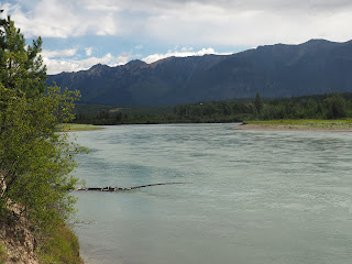
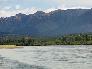
Further on, the rain stopped but the highway was still wet. I stopped at a rest stop beside the Kootenay River to take photos. Across the valley to the east the west face of the Rocky Mountains reached for the sky. The Kootenay River was wide and flowing quickly. The sky did not look promising but on a motorcycle there are not many options when one is on the road. Still, as in many places on this part of the world, the scenery is impressive.

Kootenay River looking toward the Rocky Mountains to the east.

Closer view of the Rocky Mountains over the Kootenay River

This is amazing country with stunning sights around many curves. I passed through Skookumchuck, but the only thing I saw there was the pulp mill, but the name it too good to leave out of my narrative. Along the Kootenay River further on I came across what looked like gravel cliffs. I wasn't able to stop because the shoulder of the highway are too narrow to safely stop. 

The rain held off but the clouds were threatening. I stopped for a short break in the village of Canal Flats. There isn't much here but it seems to be growing with a large building being constructed on the edge of the village. Looking toward the east, the sky was clear with clouds. To the north, however, the clouds were heavy, low and threatening. I was riding to the north so I was somewhat concerned about the possibility of heavy rain.

The view to the northeast from Canal Flats

The clouds where I was going to be riding were threatening.

I left Canal Flats and stopped at rest area overlooking Columbia Lake, which is source of the Columbia River which enters the US and reaches the Pacific Ocean. It is an experience that makes one realize how insignificant we really are when we can see the headwaters of a river that runs hundreds of kilometres before emptying into the ocean at Astoria OR. 

Columbia Lake

Columbia Lake with an information sign.

The final stage of the ride to Invermere was done in light sporadic showers. I arrived at the hotel well before check in time, but my room was ready so I was able to check in. As I unloaded my motorcycle the rain came down with big drops and lots of them. By the time I was in my room, the parking lot was full of running water. I made to my room with just minutes to spare. The mountains were almost hidden by a curtain of rain, but within half an hour the sun reappeared and the temperature rose into the mid-20s C.
Rain storm to the east

Rain storm to the north for the motel.

Having some time to use to explore, I walked around the downtown. There are some old buildings here but there doesn't seem to be a concerted effort to make the place more attractive to the tourists who come for the lake in the summer and Panorama Resort in the winter. The town of Invermere is in a beautiful setting but to me it isn't really as attractive as it might be. However, I don't live here so I really have no say in the matter. Here are some photos of the downtown, so if you read this you can make up your own mind.

The clouds have parted

7th Avenue, Invermere, BC

7th Avenue, Invermere, BC
Metal art on the wall of a gift shop, Invermere, BC

On balance the day went relatively well, concerning the cool temperature and the intermittent rain. A mitigating factor that kept the ride from being a miserable experience was that the ride was a short run of less than 175 kilometres. It is great to have some time to do some exploring without any time pressure. Tomorrow will be a longer ride to the Trans Canada Highway through Golden and Revelstoke, the south to Vernon. And the weather promises to be better.