Biggs Junction, because it is at the intersection of two major highways and consequently, all night long there was heavy tuck traffic. The truck stop across the highway was also busy with trucks refueling and sitting idling in the parking lot. While the noise from all this activity was not overpowering, the subliminal noise was noticeable. However, there were limited choices for places to stay and we had a decent room.
The morning dawned with solid cloud and cooler temperatures and we were on the road shortly after 8:00 a.m. Highway 97 climbs out of the river valley is a series of S-turns and after several kilometres and about 1500 feet (450 metres) of elevation change we were in open country. Considering the amount of truck traffic that we saw, we made good time. The terrain changed from the south side from open country to rolling hills with a plethora of basaltic outcroppings from the eastern Washington basalt flows between 17 and 14 million years ago. The extent of these basalt flows is huge, covering parts of several US states. In many places the layers are plainly visible from successive eruptions.

Biggs Junction this morning
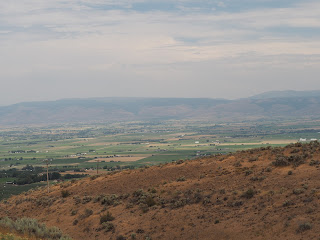
The highway dipped down from the higher elevation to the valley where Ellensburg, WA, is situated. The pullout for the scenic view gives a panoramic vista of the valley.
Ellensburg vista
Ellensburg, WA, vista
In the hills above Ellensburg, WA
We continued on north after a brief stop in Ellensburg and made it to Yakima. We had real difficulty finding Starbucks because my GPS was pointing me in the wrong direction. I got directions from a young lady at a motorcycle shop. While were there I was approached by an older gentleman. He asked if I wore leathers in this hot weather. When I told him that I wore them all the time he said he did too and showed me a photo of him and his Yamaha Royal Star.
Mike asked me if I had ever seen he movie Easy Rider. When I told I had, he volunteered that after he saw it, he rode his 1947 H-D on essentially the same route from Los Angeles to New Orleans that the characters in the movie had taken. Quite a story. He was a pleasant guy and left us with the advice to 'Keep the shiny side up.'
Before we left Yakima we visited Apple State H-D. Garry bought a coffee mug and a litre of H-D oil. The people there were friendly and helpful with directions back to Highway 97.
Apple State H-D, Yakima, WA
Hills surrounding Yakima, WA
When we left Yakima, we rode north to join I-90 east to Vantage, WA. We crossed the Columbia River once again and climbed out of the valley. The landscape is very similar to the other high desert areas that we have seen earlier. We pulled in the scenic viewpoint over the Columbia River. At the edge of a cliff the state has placed a wild horse memorial. The sculptures are silhouetted against the sky. The sight is quite memorable.
Wild horse memorial above the Columbia River, near Vantage, WA
The vista over the Columbia River and the bridge crossing it provide evidence, if any is needed, of the insignificance of the works of humans. Around fifteen thousand years ago this gorge was carved by the Lake Missoula floods when the lake burst through a glacial ice dam and flooded the Columbia all the way its mouth near Astoria, OR.
Columbia River I-90 crossing near Vantage, WA
Basalt layers above the Columbia River near Vantage, WA
The GPS took us toward Omak in ways that I had difficulty understanding. We stopped in a small town called Ephrata. The highway took us through a basaltic gorge around Lenore Lake. The terrain was extremely rugged with the ubiquitous basalt layered outcroppings. Garry suggested that we should go back to the visitor centre to see the lake and cliffs, but I wanted to press on I regret that decision now. I should have agreed , but that can't be undone. The route we took back to Highway 97 seemed, after looking at the map, to be extremely convoluted, but eventually we did get back to the highway.
We were near the Grand Coulee Dam but didn't go to see it. However, we did stop to see the Chief Joseph Dam on the Columbia River. This is a large power generating facility near Bridgeport, WA.
Chief Joseph Dam
Columbia River Bridge at Bridgeport, WA
Closer view of the bridge over the Columbia River
View of the dam from the visitor centre
One of the turbine spinners from the Chief Joseph Dam powerhouse.
We were quite close to Omak, our destination for the day's ride. When we arrived in Omak, we tried to get a room. This was difficult but we were able to get a room in a somewhat downscale motel. The room was adequate but the chair was filthy, some of the vinyl flooring was liftin, and we were besieged by a swarm of houseflies which I gradually dispatched. When we returned from dinner there was water on the floor from the air conditioner. I have stayed in better places. The air conditioning did work and that was good because it was 39C at 5:00. It was probably hotter earlier.
Tomorrow will be a more relaxed day. We will be riding the North Cascades Parkway from Twisp & Winthrop to Mount Vernon in western Washington. We are now getting close to home.


No comments:
Post a Comment